Because tectonic plates are continually shifting shape, the surface of the Earth resembles a dynamic puzzle. Made when these massive slabs of granite fall, drift, and collide with one another are some of the most exquisite and potent geological features on Earth. This article lists the ten most famous sites on Earth where tectonic plates collide. These sites highlight how raw energy of the crust is utilized. From the volcanic landscape of Iceland’s Mid-Atlantic Ridge to the earthquake-prone San Andreas Fault in California, plate tectonics has produced a great spectrum of natural beauties all around. Famous locations like the Himalayas, created when the Indian and Eurasian plates collided, and the Pacific Ring of Fire, home of active volcanoes resulting from subduction zones, are expected to be visible here.
These tectonic plate boundaries not only have incredible geologically but also alter surroundings, civilizations, and personal power. Using phrases like tectonic plates, plate boundaries, earthquake, volcanoes, subduction zones, and continental drift, this journey transports you through some of the most active sites on Earth. Scientists as well as visitors find these sites fascinating; examples include the undersea trenches of the Mariana Islands and the stunning rifts in East Africa’s Great Rift Valley. Discover the forces sculpting our planet and the reasons these tectonic hotspots are must-sees for everyone fascinated in Earth’s constant mobility.
Here Are Top Ten Places Tectonic Plates Meet
10. Queen Charlotte Fault

Stretching along the rugged coast of western Canada and southeastern Alaska, the Queen Charlotte Fault is a striking example of a transform tectonic plate boundary. Here, the Pacific Plate slides past the North American Plate in a right-lateral strike-slip motion, creating a 900-km-long fault system. This movement, at a rate of over 50 mm per year, fuels significant seismic activity, with seven magnitude 7+ earthquakes recorded in the last century. Notable events include the 1949 M8.1 quake and the 2012 M7.8 Haida Gwaii earthquake, which triggered tsunami warnings.
The fault extends northward as the Fairweather Fault, forming a complex system with varying convergence rates. Its offshore location and steep underwater escarpments make it a hotspot for studying submarine landslides and tsunami risks. The 1958 M7.8 quake caused a massive tsunami, with waves reaching 524 meters, underscoring the fault’s destructive potential. This tectonic boundary is critical for understanding seismic hazards in the Pacific Northwest, drawing researchers and geologists to its dynamic processes.
9. Mid-Indian Ridge
Deep beneath the Indian Ocean, the Mid-Indian Ridge is a vital divergent tectonic plate boundary, part of the global mid-ocean ridge system. This underwater mountain range stretches from the South Atlantic, splitting near Rodrigues Island into branches that extend to the Gulf of Aden and the Macquarie Islands. Known as the Carlsberg Ridge in its northern section, it separates the African, Indo-Australian, and Antarctic plates.
The ridge’s rough topography and thin sediment cover signal active tectonic processes, with magma rising to form new oceanic crust. Its spreading rate varies, typically around 2–5 cm per year, driving seismic activity along a belt of earthquake epicenters. This region is crucial for studying oceanic crust formation and plate tectonics, with its remote underwater setting offering unique challenges for researchers. The ridge’s connection to the East African Rift highlights its role in global tectonic networks, making it a key area for understanding how continents drift and oceans form over millions of years.
8. Andes Mountains

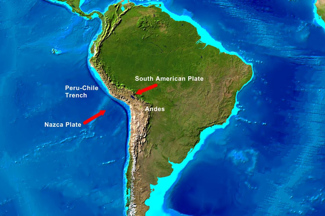
The Andes Mountains, the world’s longest continental mountain range, span 8,900 km along South America’s western edge, from Venezuela to southern Chile. Formed by the convergent tectonic plate boundary where the Nazca and Antarctic plates subduct beneath the South American Plate, the Andes are a geological marvel. This subduction, ongoing for over 200 million years, creates intense volcanic activity and frequent earthquakes. Aconcagua, at 6,961 meters, is the range’s highest peak, while the Altiplano Plateau hosts cities like La Paz.
The Andes feature stratovolcanoes like Chimborazo and significant mineral deposits, including copper and lithium. Seismic events, such as the 2010 M8.8 Maule earthquake, highlight the region’s volatility. The range’s three segments—Northern, Central, and Southern—each showcase unique geological features, from tropical glaciers to arid plateaus. The Andes shape South America’s climate, rivers, and cultures, making them a focal point for studying plate tectonics and their impact on human populations and natural resources.
7. Alpine-Himalayan Belt

The Alpine-Himalayan Belt, or Alpide Belt, is a vast convergent tectonic plate boundary stretching 15,000 km from Java to the Atlantic. Formed by the collision of the African, Arabian, and Indian plates with the Eurasian Plate, it accounts for 17% of the world’s largest earthquakes. This belt includes iconic mountain ranges like the Alps, Atlas, Caucasus, and Himalayas, shaped by the closure of the ancient Tethys Ocean. The collision creates folded mountains and thrust faults, with ongoing tectonic activity driving seismic risks.
The Alps, for instance, result from Africa’s northward push, while the Himalayas mark the Indian Plate’s collision. The belt’s diverse geology, from Mediterranean islands to Central Asian peaks, makes it a hotspot for studying orogeny and plate tectonics. Historical studies by Eduard Suess in the 19th century laid the groundwork for understanding its complex structure. Its seismic activity and stunning landscapes draw geologists and adventurers alike, offering a window into Earth’s dynamic crust.
6. Mariana Trench

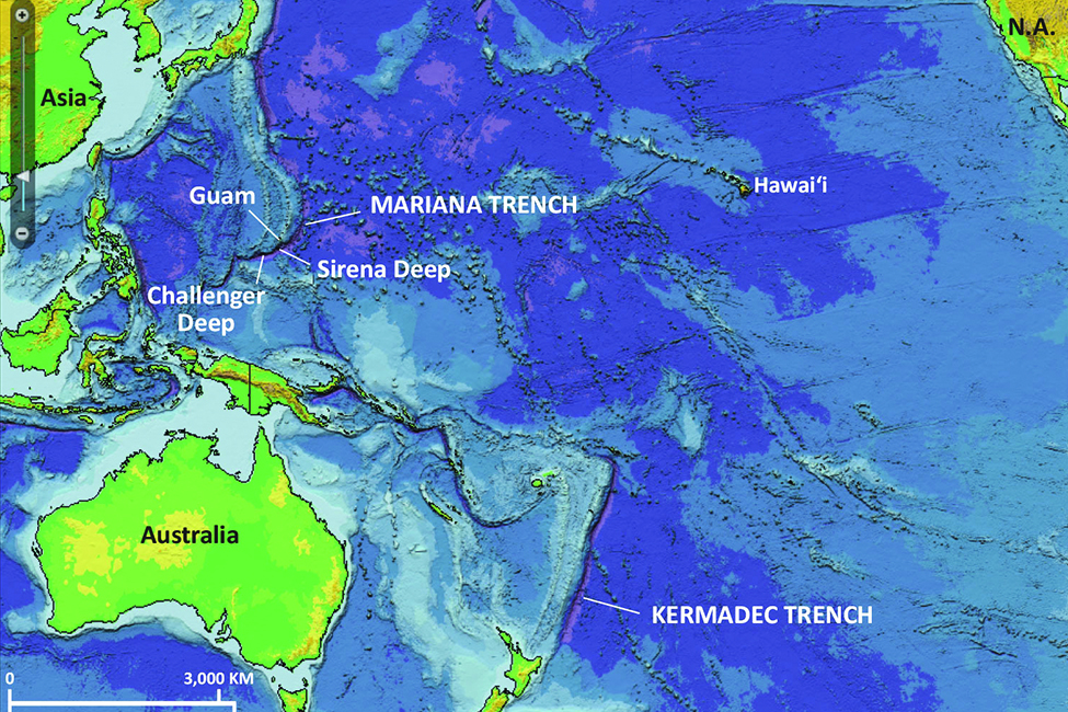
The Mariana Trench, located in the western Pacific east of the Mariana Islands, is the planet’s deepest oceanic trench, formed by the subduction of the Pacific Plate beneath the Mariana Plate. This convergent tectonic plate boundary stretches 2,550 km, with the Challenger Deep reaching 10,984 meters—deeper than Mount Everest is tall. Extreme pressure and near-freezing temperatures create a harsh environment, yet unique life forms like snailfish and amphipods thrive.
Established as a marine national monument in 2009, the trench has seen historic explorations, including Jacques Piccard’s 1960 descent and Victor Vescovo’s 2019 dive. The subduction process fuels seismic activity and volcanic arcs nearby, making it a key site for studying plate tectonics and deep-sea ecosystems. Environmental concerns, such as plastic pollution found at its depths, highlight the trench’s global significance. Its mysterious depths continue to captivate scientists, offering insights into Earth’s geological and biological extremes.
5. East African Rift

The East African Rift is a dramatic divergent tectonic plate boundary where the African Plate is splitting into the Somali and Nubian plates. Stretching over 3,000 km from the Afar Triple Junction to Zimbabwe, this rift is creating a new ocean basin. Active for 22–25 million years, it features deep valleys, steep escarpments, and volcanoes like Erta Ale and Ol Doinyo Lengai, the world’s only active natrocarbonatite volcano.
The Great Rift Valley hosts Africa’s Great Lakes and key archaeological sites tied to human evolution. With a spreading rate of 6–7 mm per year, the rift’s tectonic activity is driven by mantle plumes, potentially linked to the African superplume. Its stunning landscapes, from Ethiopia’s Danakil Depression to Tanzania’s Ngorongoro Crater, make it a focal point for studying continental drift and plate tectonics. The region’s geological dynamism and biodiversity draw researchers and travelers eager to witness Earth’s future oceans in the making.
4. Pacific Ring of Fire
Encircling the Pacific Ocean, the Pacific Ring of Fire is a 40,000-km-long zone of intense seismic and volcanic activity. This convergent tectonic plate boundary involves multiple plates, including the Pacific, Nazca, and Philippine, subducting beneath surrounding plates. Home to 750–915 volcanoes—two-thirds of the global total—and 90% of the world’s earthquakes, it includes volcanic arcs like the Andes, Cascades, and Japan’s islands. Major eruptions, such as Mount St. Helens in 1980, and massive quakes, like the 2011 M9.0 Tohoku earthquake, underscore its power.
Subduction zones create deep oceanic trenches and fuel stratovolcanoes, shaping diverse landscapes. The Ring of Fire’s geological activity influences global climate and human settlements, making it a critical area for studying plate tectonics and natural hazards. Its dramatic features, from Alaska’s Aleutian Islands to Indonesia’s Krakatoa, captivate those exploring Earth’s fiery nature.
3. Himalayas

The Himalayas, the world’s highest mountain range, were born from the convergent tectonic plate boundary where the Indian Plate collides with the Eurasian Plate. This collision, starting 50 million years ago, created a 2,400-km-long range across Nepal, India, Bhutan, China, and Pakistan. Mount Everest, at 8,848.86 meters, is its crown, joined by over 100 peaks above 7,200 meters. The range rises 5 mm annually due to ongoing tectonic pressure, fueling seismic activity.
Home to 15,000 glaciers, the Himalayas feed major rivers like the Ganges and Indus, supporting millions. Earthquakes, such as the 2015 Nepal M7.8 quake, highlight the region’s volatility. Its diverse ecosystems, from alpine meadows to subtropical forests, and cultural significance make it a global treasure. Studying this tectonic boundary offers insights into mountain-building processes and plate tectonics, drawing scientists and adventurers to its majestic peaks.
2. San Andreas Fault
.png)
Running through California and into Mexico, the San Andreas Fault is a transform tectonic plate boundary where the Pacific Plate slides northwest past the North American Plate. This 1,200-km-long fault, with a slip rate of 20–35 mm per year, is infamous for its earthquake activity. The 1906 San Francisco earthquake (M7.8) and 1989 Loma Prieta quake (M6.9) caused significant damage, highlighting its seismic risk.
Divided into northern, central, and southern segments, the fault’s right-lateral strike-slip motion shapes California’s landscape, from coastal cliffs to inland valleys. Research, like the San Andreas Fault Observatory at Depth (SAFOD), provides data on seismic behavior, aiding preparedness. Its visibility in places like Carrizo Plain, where offset streams reveal past quakes, makes it a living laboratory for plate tectonics. The fault’s cultural and scientific significance draws global attention to its role in shaping Earth’s crust.
1. Mid-Atlantic Ridge

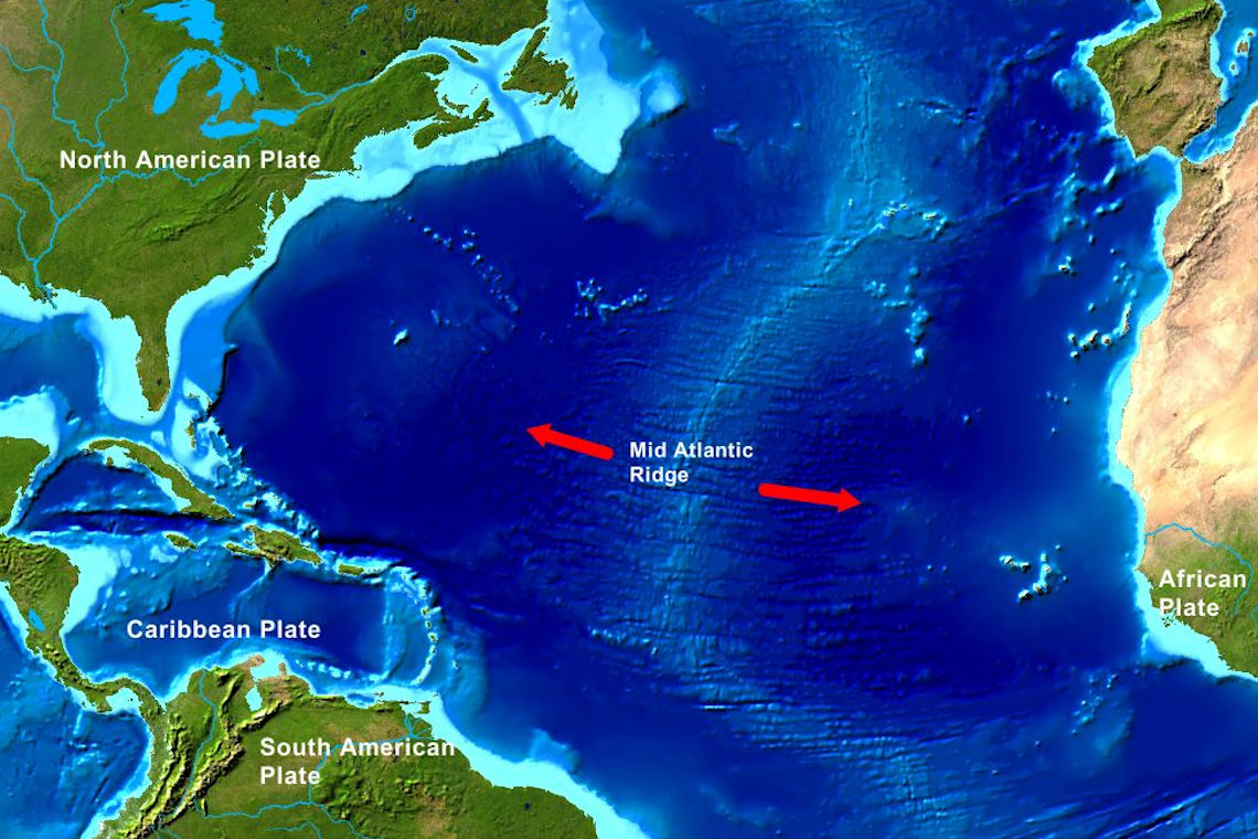
The Mid-Atlantic Ridge, a divergent tectonic plate boundary, stretches along the Atlantic Ocean floor from the Arctic to the Southern Ocean. This massive underwater mountain range, where the North American, Eurasian, and African plates pull apart, creates new oceanic crust at a rate of 2.5 cm per year. Uniquely, it emerges above sea level in Iceland, where visitors can walk between plates at Thingvellir National Park.
The ridge’s hydrothermal vents support ecosystems with extremophiles, like tube worms, thriving in harsh conditions. Its rugged topography and thin sediment cover mark it as a hotspot for studying plate tectonics and oceanic crust formation. Seismic activity and volcanic eruptions, such as those in Iceland’s Reykjanes Peninsula, highlight its dynamic nature. The ridge’s role in continental drift and seafloor spreading makes it a cornerstone of geological research, offering a glimpse into the forces reshaping Earth’s surface over millions of years.

